If you are a CILTI member and received this summer’s newsletter, you probably noticed the unique vantage point of our cover photo. Seen from the sky, our cover shot showed the stewardship team hard at work, planting young trees on the edge of a lush forest in Parke County. To capture this photo, we used a relatively new tool (or some might say toy): a drone.
The stewardship team dubbed the drone Kermit, a name inspired by its froggy shadow (and also a tribute to writer and explorer Kermit Roosevelt), and Kermit has already earned its keep in stew crew’s toolbelt.
A drone is one form of unmanned aerial vehicle (UAV). Its controller is set up a bit like a video game controller, accessed from a smartphone. The phone screen displays what the camera on the drone is seeing, as well as aircraft height, distance from “home” (takeoff point), and a little map in the corner that tracks the path of flight.
So far, we’ve mainly used the drone to gather visuals of pieces of land. We use these visuals to quickly monitor, map and track changes in vegetation across the landscape without the need for a complete technical mastery of geographic information systems (GIS). A GIS is a computer system that uses geographically referenced information—such as an image taken from above linked with features on a map—to create, manage, analyze and map data.
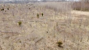
One of the most striking examples of Kermit’s use so far was at Nonie Werbe Krauss Nature Preserve. There, we have benefited from an aerial view of our callery/Bradford pear eradication efforts.
In 2008, CILTI started planting an oak-hickory dominant forest on 26 acres of the nature preserve. Fast forward to 2020: callery pear were taking over, threatening the overall health of the planting.
We didn’t have Kermit in 2020 to assess the preserve before we began treating for invasive pears, so we won’t have before and after imagery, but our aerial footage of the planting area while callery pears were in bloom helped us identify and target hotspots. What would have taken half a day or more to assess from the ground was done in a half hour via drone.
I know what you’re thinking: “Wow! That’s incredible! What else can you do with drones?” Well, we can:
- share what we have learned with other conservation professionals, teaching our own restoration methods with visuals
- support grant reports with images and footage
- compile before and after visuals of reforestation projects, burns, and the like
- distinguish between land uses and create fine-scale mapping for density and distribution of species
- monitor large and difficult-to-access conservation easements, like the newly protected Sugar Mill Creek CE
- show others the scope of what we are doing, as with our cover photo of a tree planting
For now, monitoring our tree plantings and invasive species projects are Kermit’s main tasks. And for all its usefulness, it has one more bonus feature: it’s really fun to pilot!

Grace van Kan
White River Steward